
As captain of the Bay Guardian, Tracy Valenta is out plying the waters of Green Bay at least twice a week. From her sturdy research vessel, Valenta studies Green Bay for NEW Water, the City of Green Bay’s municipal sewage district. It’s the most extensive water quality monitoring effort in the region, working from the mouth of the Fox River out beyond where cleaner upper bay waters mix with the more polluted waters of the southern bay.
If there’s something happening in the waters of Green Bay, Valenta knows about it. In early August of 2005, she got a phone call from the Wisconsin Department of Natural Resources asking for any information she might have about why massive numbers of gobies, a small invasive fish, had been spotted huddling up on the eastern shore of Green Bay near Bayshore County Park.
NEW Water had a continuous monitoring buoy that happened to be near the goby sightings, and on her next sampling trip Valenta pulled the recorded data. Looking back over the readings, the problem was easy to spot: There was very little oxygen on the floor of the bay. Bottom dwellers who can’t swim up the water column, the gobies had been forced toward the shallow shore in search of oxygenated, breathable water.
According to the official Wisconsin Department of Natural Resources report, the gobies were “all clumped up, often resting on large rocks in such dense concentrations that you couldn’t see the rock … [with] all their heads pointing in the same direction, like scales on a fish.”
The goby event was concrete evidence of a problem long suspected in the waters of the bay: a “dead zone” of bottom-hugging, oxygen-depleted water incapable of sustaining aquatic life.
A gateway to Lake Michigan and home to one of the world’s largest freshwater estuaries, Green Bay is no stranger to water quality problems. Efforts to clean up polychlorinated biphenyls (PCBs) discharged in the Lower Fox River and Green Bay by area paper mills during the 1950s and 1960s have been ongoing for the last few decades.
The confirmation of an expanding dead zone in the bay was not welcome news to an area reeling from years of arguments over who should pay for environmental remediation. It posed an uncomfortable question to the people of Green Bay and the Fox Cities: After all the clean-up work and almost a billion dollars in remediation funds, what if this important ecosystem is still broken?
>>><<<
If you are a strong swimmer, and a curious one, then you have probably experienced the simple physics at the heart of the dead zone problem. You can feel it best in the summer time, when you take a deep breath and dive into almost any of the deeper lakes in Wisconsin. At a certain point in the dive, water temperature begins to fall; this area is called the thermocline. And if you get deep enough, it suddenly gets quite cold; this is the hypolimnion.
The warm water is easy to explain: contact with summer air and the sun warms lake surface waters. But because warm water is lighter than colder water, it also floats on top. And if the difference in temperature between the top and the bottom gets too great—if the thermocline gets too steep—it becomes virtually impossible for wind to mix the two layers of water. When this happens, the hypolimnion is virtually sealed off from the atmosphere. Without any circulation, the oxygen on the bottom is quickly depleted by decaying organic matter. While some animals can swim up or out of the hypolimnion to find oxygen, others are stranded there and die. This is how dead zones occur.
Strictly speaking, dead zone isn’t an entirely accurate term to describe this phenomenon because some aquatic dwellers—for example, some worms and midge larvae—aren’t very sensitive to oxygen depletion. And, in the case of Green Bay, these episodes of low to no oxygen don’t always last long enough to completely change the ecosystem.
Scientists prefer the term hypoxia to describe episodic low- to no-oxygen events. Hypoxia is known to occur as well in places like Lake Erie and the Gulf of Mexico, the latter of which has a dead zone approximately the size of New Jersey that begins near the mouth of the Mississippi River. For the purpose of this report, we’ll stick with popular term dead zone.

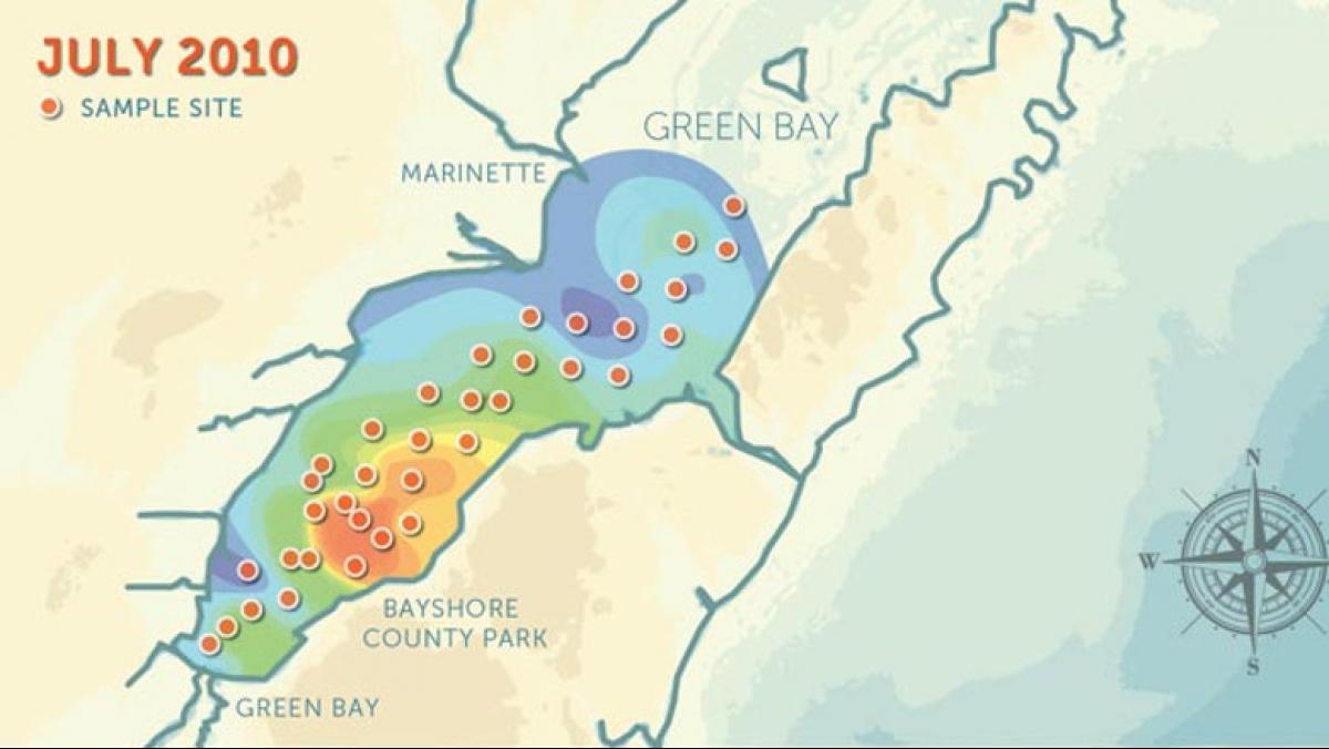
The dead zone begins near Dyckesville, which is located to the north of the city of Green Bay. From there the zone can extend for miles to the north and south, sometimes reaching as far as the mouth of the Fox River. The challenge in monitoring the dead zone is that it is mobile, expanding and contracting when variables like wind, water temperature, and other factors combine to mix bay waters and return oxygen to the bottom layers.
“It is one of the most important components of water,” says Valenta, marveling at the bay organisms that can survive for days without oxygen. “We wouldn’t survive with a plastic bag on our head for ten minutes.”
Yet without indicators such as large fish kills, dead zones can go unnoticed for years.
The work of water researchers like Valenta has brought much attention to the dead zone, but there is evidence that Green Bay has struggled with hypoxia since the 1950s. Low levels of oxygen were reported in the lower bay during the late summer months beginning in 1939. In August of 1974, samples of bay waters taken as far as three miles out from the mouth of the Fox River showed oxygen levels of zero.
While the amount of oxygen an aquatic system needs to function can vary according to location and temperature, in Green Bay, which is classified a warm water sport fishery, anything below five milligrams per liter is considered compromised. Valenta’s data from 2005 showed seven events (most lasting a few days) where oxygen dipped below this threshold.
Panicked gobies surfaced near Bayshore Park again in 2011, but this year the problem was much worse. At the end of July, dissolved oxygen was at or near zero, where it remained for almost two weeks. It didn’t climb back to safe levels until the middle of August. Then it plummeted back down, see-sawing over the divide, with only brief breathable periods until September.
While hypoxia varies across the bay, by looking at one particular location over time it is easy to see the numbers are rising: four hypoxic days in 1990 and seventeen in 2005. From 2009 to 2011 the count continued to rise, from 28 days to 39 and on to 43.
>>><<<
To understand what is happening to the oxygen in the dead zone, we first need to understand what is happening on the land surrounding Green Bay.
Once upon a time, phosphorous from industrial processes and untreated sewage flowed unabated into the waters of the Fox River and Green Bay. But these inputs have been steadily declining, and Green Bay’s sewage treatment plant now accounts for only 2% of the phosphorus entering the bay.
The major source of pollution today is the sediment and phosphorus that runs off of farm fields, residential lawns, and city streets every time it rains.
“What you see in the water is a direct correlation to what’s happening on the land,” says Valenta. “If you see green water, [that means] there are nutrients and sediment running off the land into the water,” fueling algal growth.
Every year 132,000 metric tons of nutrient-rich sediments enter Green Bay via the Fox River. This is roughly equivalent to 27 dump trucks emptying mixed loads of silt, plant debris, and phosphorus off the Leo Frigo Memorial Bridge and into the Fox River—seven days a week, 365 days a year.
The nutrient-rich runoff fuels explosive algae growth in the waters of the bay. When algae dies, it falls to the bottom of the bay where microbes and other organisms working to break it apart significantly increase the demand for oxygen, choking off bottom-dwelling animals and creating a hypoxic dead zone.
Because phosphorus can come from anywhere, the technical challenge is tracing it to its source. This job falls to University of Wisconsin–Green Bay scientist Kevin Fermanich and his collaborators.
While leaf and lawn debris, as well as the overuse of yard fertilizers, are urban sources of phosphorus pollution, one of the bay’s biggest problems is the large phosphorus load carried by Plum Creek, says Fermanich.
Originating in the Forest Junction area and flowing north to Wrightstown, where it empties into the Lower Fox River, Plum Creek meanders through a largely agricultural area that happens to be a little hillier than average. From years of manure spreading, many of the area fields have far more phosphorus than plants can use. In 2011, during a heavy April storm, water rolled brown through the Plum as rain dislodged soil and applied manure from fields with little or no plant growth. Even to a non-scientist, the subsequent storm-washed plume of brown water that appeared in the bay clearly was a sign of something wrong.
That image of the brown plume spreading across Green Bay is a good reminder that phosphorus pollution is an event-driven phenomenon. In 2011, 79% of the phosphorus entered Green Bay in eight storm events over the course of just fourteen days. Drier years are cleaner simply because less rain washes across the landscape. “One mis-timed two-inch rainfall could [lead to] the highest loading of the year,” says Fermanich. In other words, luck alone can play a big role.
But that’s not to say we can’t do better.

“We’ve got a vulnerable landscape because of the nature of our farming enterprises,” says Fermanich, pointing to the region’s massive dairy and corn-growing operations. “We need to create healthier soils in our watershed, ones that are more resilient and less vulnerable to erosion.”
Some progress is being made in soil management, most notably a pilot project launched by the Oneida Nation and NEW Water. They’re studying the Silver Creek watershed, where the Oneida own more than half of the agricultural land and have the authority to impose stricter management practices like reducing row crops, reducing dependence on corn-feed with managed grazing, introducing cover crops, and creating buffers between agricultural lands and the creek.
But between the technical challenges and the vast amount of phosphorus stored in fields, streambeds, and bay sediments, Fermanich wonders if these changes will be enough.
“I’m not very confident that we can actually meet the water quality criteria that’s currently set,” he says, noting that there is no way to know if the bay-area citizens—both rural and urban—will respond to the call.
One thing is clear, he says, and that is the need for the community to persevere. “We need to improve the communication [between scientists and the public], and build the sense that we’re all in this together.”
>>><<<
Green Bay is a complicated ecosystem, and overseeing the massive computations needed to predict how the dead zone might respond to human tinkering is Val Klump. Klump has studied Lake Michigan for more than thirty years from his post at the Great Lakes WATER Institute at the University of Wisconsin–Milwaukee.
Klump says that the bay is a very effective trap for the pollution that flows down the Fox River, allowing only 30% of the pollutant load to enter Lake Michigan. While that’s good for Lake Michigan, the 70% of the load left behind is not good for Green Bay. Klump estimates that in order to address the dead zone problem, we need to reduce overall bay pollution by about half. He says the challenging piece of the puzzle right now is climate change, which seems likely to make the problem worse.
“This area is predicted to be both wetter and warmer, and both of those things tend to exacerbate the problem,” explains Klump. Warmer weather means longer periods where the lake is stratified, with warm water trapping the cool bottom waters. The extra precipitation is expected to fall in bigger storm events. Under current land conditions, this means more runoff, more pollution, and more algae.
Changing weather patterns have already exacerbated the hypoxia problem. Over the last decade the prevailing direction of storms in the bay has shifted from the northwest to the southeast. In addition to the shape and depth of a lake, mixing is partly influenced by wind direction and speed, and this change in weather reduces mixing potential.
What will it take to improve this situation as changes in climate continue? Klump is overseeing the building of many models: how the water moves, where the climate is going, how the oxygen is used, and where the phosphorus goes.
“All these models need to be linked in order to estimate what it’s going to be like,” he says.
Like UW–Green Bay’s Fermanich, Klump is not sure we can repair the dead zone in the short run. But he’s happy with the new regulatory tools and the public response to the media’s recent coverage of the dead zone.
>>><<<
Repairing the dead zone would lead to cleaner water, reconstituted fisheries, and an overall healthier Green Bay and Lake Michigan. But fixing just one part of the problem won’t work.
To understand this intertwined ecosystem, we need to get to know genus Hexagenia. Three species of Hexagenia—better known as the giant mayfly—used to call Green Bay home. And, for a few nights every summer, mayflies owned the bay, hatching out in untold billions.
According to Jerry Kaster, senior scientist at the Great Lakes WATER Institute, mayflies spend one or two years in a small U-shaped burrow in the mud of the bay bottom before molting and leaving the water en masse on a very calm summer night. This is called the subimago emergence, unique to mayflies because they still must molt one more time on land. They then fly out over the water and reproduce, mating in mid air. Billions of eggs fall to the lake, sinking to the bottom and starting the cycle again.
Kaster says that the mayflies disappeared from the bay in the late 1950s, a casualty of phosphorus pollution. While these insects don’t deal well with hypoxia, Kaster also believes that they are hindered by the accumulation of algal sediments on the bay floor that are too loose to support mayfly burrows. Kaster is experimenting with techniques like the introduction of algae-eating freshwater oligochaetes (a kind of worm) that might help restore the mayfly population by consolidating the oozy bottom of the lower bay.
It’s an interesting way of combating the dead zone, and one that excites Valenta, who sees the giant mayfly as Green Bay’s missing charismatic megafauna.
“They used to hatch by the truckload,” she says. “Imagine the fisheries that we would have if we actually had giant mayfly larvae for our fish to eat instead of bloodworm—which they can’t eat for a large portion of the summer because the fish can’t breathe down there.”
The mayfly won’t return overnight, Valenta cautions: “This is not an easy fix.” But cleaning up phosphorus would have major benefits for the entire bay. Sediment reduction begets phosphorus reduction, which begets algae reduction, which in turn improves water clarity. Rooted aquatic plants rebound, mayflies recover, and fisheries prosper and support bird and small mammal populations around the bay.
“I do feel optimistic,” she adds. “Just the fact that we’re having this conversation right now is huge. But I hope these conversations lead to action.”